
(PCC) Program on Chinese Cities – Thoughts on Overseas Travels Series
Authors: Yan Zhang,
Associate Professor at the School of Architecture and Urban Planning, Shenzhen University, and visiting scholar in the Department of Regional and City Planning at the University of North Carolina. Email: zhyan607@126.com
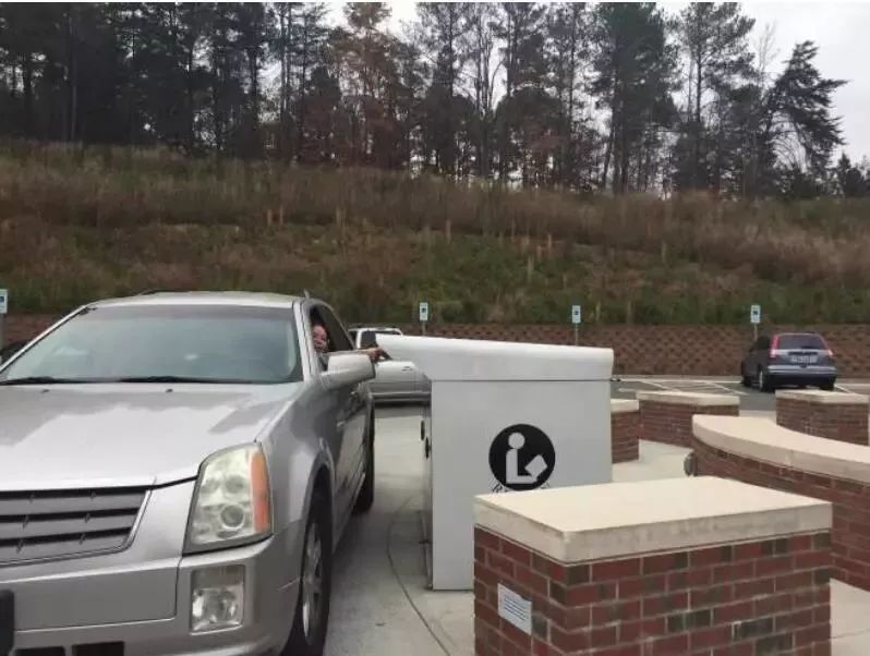
The United States is often called a “nation on wheels,” with high rates of car ownership and usage. In cities, it is common to see designs that cater to the convenience of car users, such as drive-through facilities at libraries, banks, and fast food restaurants where people can return books, withdraw money, or order food without leaving their cars (Figure 1). In such an environment, developing public transit is not an easy task.
The town of Chapel Hill, where I am a visiting scholar, thrives on the University of North Carolina at Chapel Hill (UNC). It covers an area of 21.1 square miles (approximately 55 km²) with a total population of about 60,000 people (Figure 2). Households without a car account for only 11% (Table 1).


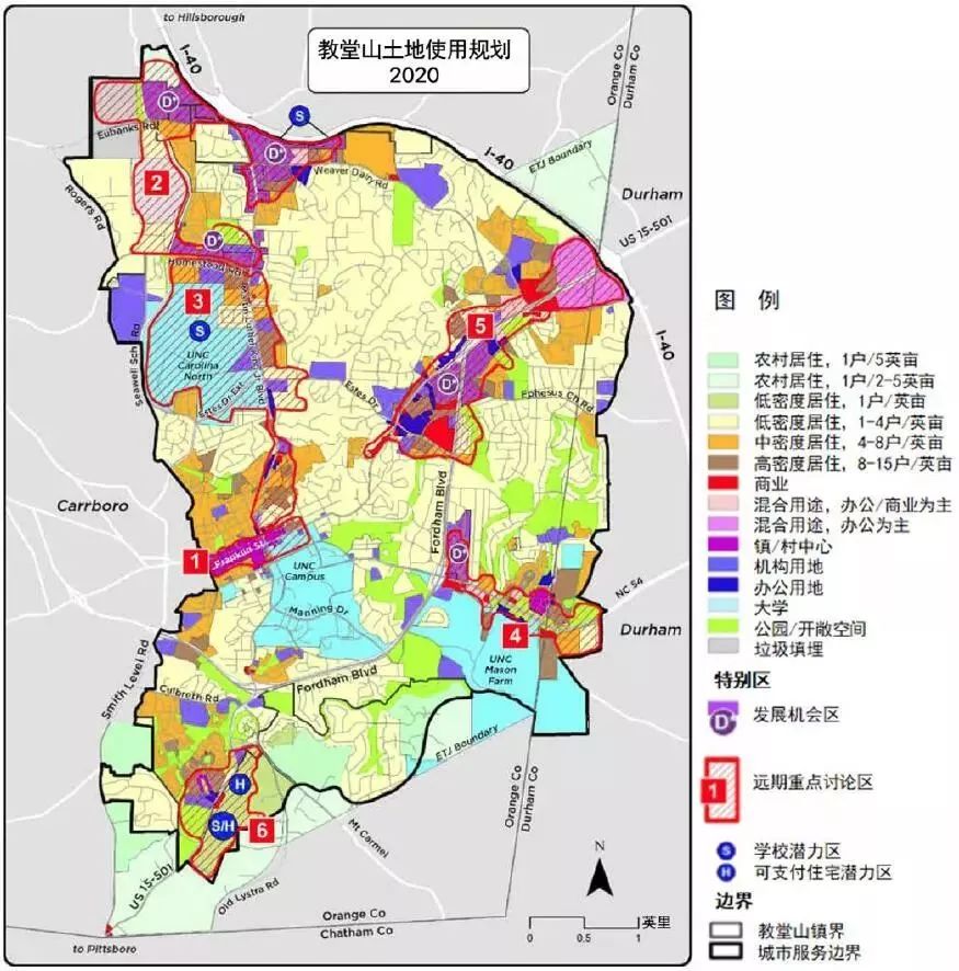
From the town’s land use planning, it is evident that constructions are quite dispersed, with large areas of low-density residential land occupying more than 50% of the town’s space (Figure 3).
According to 2015 statistics, the share of commuting by car in Chapel Hill has been declining year by year, while the share of public transit has seen a slight increase (Figure 4). It is noteworthy that in surrounding cities, car travel typically accounts for about 90%.

This trend in Chapel Hill is closely related to the town’s relentless efforts to support and develop public transportation.
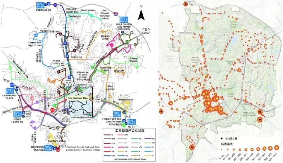
First, the public transit system is closely integrated with demographic needs. As a typical college town, about 50% of Chapel Hill’s population are students, predominantly young, with a median age of 25.6 years. The UNC campus is located near the town center, adjacent to Main Street, Franklin Street. Over 60% of students live off-campus, not only in Chapel Hill but also in the neighboring towns of Carrboro and Durham. The public transit system in Chapel Hill is designed with a focus on the travel needs of the UNC student body and local residents commuting to the town center. Current transit routes radiate mostly from UNC and the town center (Figure 5). Parking on campus and in the town center is generally fee-based on weekdays and the number of spots is limited. Many students drive to nearby public parking lots and take the bus to school. Traffic flow statistics from various stations show that the busiest stations are generally within the UNC campus and the town center, followed by stations near park-and-ride (P+R) parking lots.
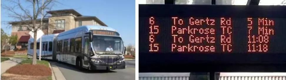
Second, high-level public transit service is provided. Since 2002, the majority of Chapel Hill’s bus routes have been fare-free. The buses are spacious, clean, and comfortable, with high ridership, especially during school rush hours when seats are often hard to find. However, the frequency of buses is not high, with an hourly service being common. To minimize waiting times, many bus stations are equipped with digital information displays (Figure 6) that accurately indicate the arrival times of the next bus. Additionally, bus schedules can be freely accessed via mobile apps, allowing people to plan their travel times efficiently and avoid wasted time waiting for buses.
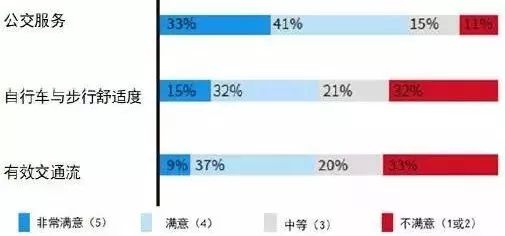
According to a 2013 community survey in Chapel Hill, residents’ satisfaction with the town’s bus services is quite high (Figure 7).
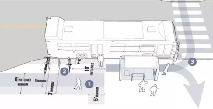
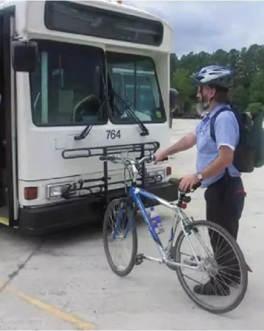
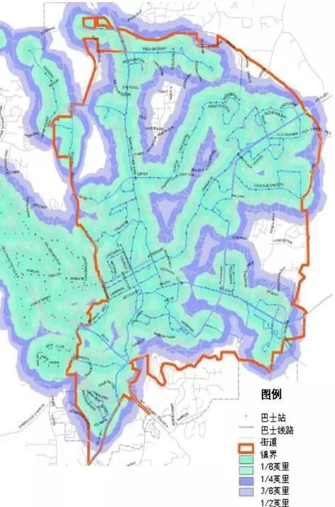
Third, Chapel Hill’s public transit places a strong emphasis on the “first and last mile” connections of the public transit corridor, considering these to be crucial for attracting users. Therefore, some bus stations near bike parking facilities are considered (Figure 8); this, along with careful design, helps to resolve conflicts between pedestrian, public transit, and bicycle traffic at these stations. Buses are equipped with bike racks at the front to facilitate passengers who wish to bring their bicycles (Figure 9). Additionally, each bus station acts as a core for various radii of buffer zones (Figure 10), which guide the timing of improvements to pedestrian paths, bike lanes, and greenways.
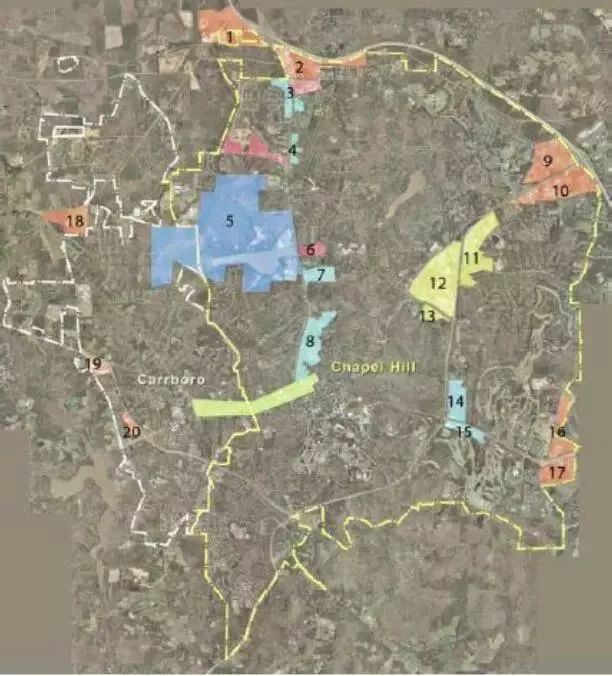
Fourth, in new land developments, support for public transit-oriented land use is highly emphasized, resulting in a Transit Supportive Development (TSD) model. Key features include (1) mixed-use and high-density development of residential, commercial, and office spaces around stations; (2) attractive, safe pedestrian environments; and (3) public spaces integrated with transit stations and commercial spaces to create a sense of place. According to medium- and long-term transport plans, Chapel Hill and the neighboring town of Carrboro have identified 20 potential TSD areas along the public transit corridor (Figure 11). Design guidelines are also provided to support the TSD model.
Today, Chapel Hill boasts the second-largest public transit system in North Carolina and the largest fare-free system in the United States, with an annual ridership of 7 million people. The transit system is operated by the town of Chapel Hill, with financial support from UNC and the town of Carrboro. “Making safe, convenient riding, walking, and public transit the everyday choice for people” has become a significant transportation goal for Chapel Hill. Integrating public transit with other modes of slow travel, improving the level of service of public transit itself, and supporting transit-oriented development… These principles, which may sound abstract, are practically implemented in the planning, construction, and operational management of Chapel Hill’s transit system, showing that even in a nation dominated by car development, transit priority is not so far-fetched.